Is It Safe to Self-Drive Through Hulunbuir in September? A Novice Driver's Complete Guide
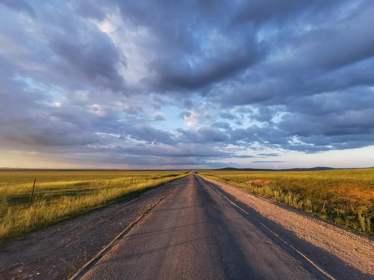
Mid-September is the most beautiful — and most deceptive — time to drive through Hulunbuir. The grasslands turn gold, the white birch forests hit peak autumn color, and the summer crowds vanish. But the same day can swing from 18°C (64°F) sunshine to near-freezing temperatures by dusk. Fuel stations can be 150 km apart. Livestock wander freely across unmarked roads. And if you've never driven anything beyond city streets, the combination of long distances, remote stretches, and unpredictable conditions can be genuinely dangerous without preparation.
This guide covers everything you need to know for a safe, enjoyable 3-day self-drive loop from Hailar Airport through Genhe (Root River) to Shiwei and back — written specifically for a novice driver in a Volkswagen Tharu SUV. We'll cover the Tharu's controls from scratch, the real weather risks, exactly where to fuel and eat, how to handle livestock on the road, and a detailed hour-by-hour itinerary that gets you back to the airport with hours to spare.
Key Takeaways
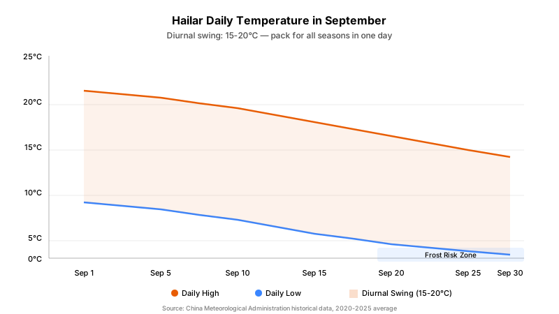
- Pack for all four seasons in one day — September highs reach 18-22°C but nights drop to 0-8°C, with a diurnal swing of 15-20°C (China Meteorological Administration, 2025).
- The Volkswagen Tharu is fully capable on paved routes — its 180mm ground clearance and 1.5T/2.0T engine handle all national highways and provincial roads; avoid unpaved border defense roads.
- Fuel stations are 100-200 km apart on grassland routes — follow the half-tank rule: whenever your gauge hits 50%, fill up at the next station.
- Livestock on the road is the #1 hazard — cattle and sheep frequently cross unmarked; never swerve around them (rollover risk), and hitting one requires police reporting with compensation of 10,000-20,000 RMB per cow.
- Day 3 takes the border defense road (the highlight) — Shiwei → Qi-Qia → Ba-Qia → Jiu-Qia → Heishantou → Hailar, ~350-400 km total. The border road is gravel/dirt (30-50 km/h), then G331 paved highway from Heishantou. Depart 07:00, arrive by 15:00 with 1 hour buffer.
What's the Weather Really Like in Mid-September?
Hulunbuir sits at roughly 49°N latitude and 600-700m elevation on the eastern edge of the Mongolian Plateau. September marks the rapid transition from summer to winter, and the weather reflects that instability.
Temperature Reality
| Metric | Early Sept (1-10) | Mid Sept (11-20) | Late Sept (21-30) |
|---|---|---|---|
| Daytime High | 20-22°C (68-72°F) | 16-20°C (61-68°F) | 12-16°C (54-61°F) |
| Nighttime Low | 4-8°C (39-46°F) | 2-6°C (36-43°F) | 0-4°C (32-39°F) |
| Diurnal Swing | ~15°C | ~16°C | ~16°C |
| Frost Risk | Low | Moderate | High |
| Snow Possible | Rare | Unlikely but possible | Possible |
The critical number is the diurnal temperature swing of 15-20°C. You might start the day in a light long-sleeve shirt and need a down jacket by evening. Early frost typically arrives in the first or second week of September in low-lying areas (China Meteorological Administration, 2025).
What This Means for Your Drive
- Morning frost on windshields is common from mid-month onward. Carry a scraper or use the defroster for 5-10 minutes before departing.
- Sudden weather changes — a clear morning can turn to rain or wet snow by afternoon, especially after September 20th.
- Wind is a constant factor on open grasslands. Crosswinds can push a tall vehicle (including the Tharu) noticeably — grip the steering wheel firmly and reduce speed in exposed sections.
- Daylight shrinks rapidly — sunset moves from ~18:45 in early September to ~17:45 by month's end. Plan to be at your accommodation before dark.
Clothing Strategy: The Layer System
Forget packing for a single temperature. You need three layers that you can add or remove throughout the day:
- Base layer: Moisture-wicking thermal top and bottom (merino wool or synthetic). Even in "warm" afternoons, you'll want this for morning starts.
- Mid layer: Fleece jacket or lightweight down vest. This is your driving layer.
- Outer layer: Windproof/waterproof shell jacket. Essential for wind and sudden rain.
- Extremities: Warm hat, gloves, and a buff/scarf. Your hands get cold holding the steering wheel at dawn.
Pack a down jacket (羽绒服) — not optional, mandatory. You'll wear it every morning and evening.
Is the Volkswagen Tharu Good Enough for This Route?
The short answer: yes, for the paved route described in this guide. The Tharu is a compact urban SUV, not an off-roader, but the roads you'll be driving (G332 national highway, S201 provincial road, and city streets) are all fully paved and well-maintained.
Tharu Specifications vs. Route Requirements
| Specification | Tharu Data | Route Requirement | Verdict |
|---|---|---|---|
| Ground Clearance | ~180 mm (unloaded) | ~150 mm minimum for paved roads | ✅ Sufficient |
| Engine | 1.5T (150 hp) or 2.0T (186 hp) | Adequate for 2-lane highways | ✅ Sufficient |
| Drivetrain | FWD standard / 4Motion AWD optional | FWD sufficient for paved routes | ✅ Sufficient |
| Tire | 225/50 R18 (typical) | Standard highway tires fine on pavement | ✅ Sufficient |
| Approach/Departure Angle | Moderate | Not needed on paved roads | ✅ Sufficient |
Where the Tharu Struggles (and What to Avoid)
- Serious off-roading: The Tharu is not a dedicated off-roader. Don't attempt river dune crossings, desert driving, or steep hill climbs. The gravel border road on Day 3 is "light unpaved" — well within the Tharu's capability.
- Driving onto grassland: Never drive off the existing track onto actual grassland — you'll get stuck, damage the ecosystem, and potentially face fines.
- Deep mud and loose gravel: After heavy rain, the border road can become muddy and slippery. Check the weather before departure; if significant rain is forecast, take the paved alternative (Shiwei → Ergun → Hailar).
- Deep water crossings: The Tharu's wading depth is ~30 cm. The border road has occasional shallow fords — do not attempt any deeper than 15 cm.
Fuel Consumption on This Route
| Condition | 1.5T (L/100km) | 2.0T (L/100km) |
|---|---|---|
| Highway cruising (90-100 km/h) | 6.0-7.0 | 7.0-8.0 |
| Mixed rural roads (60-80 km/h) | 7.0-8.5 | 8.0-9.5 |
| With AC/heating on | +0.5-1.0 | +0.5-1.0 |
With a 50-51 liter tank, the 1.5T Tharu has a theoretical range of ~700-800 km on highways. In practice, never let the tank drop below a quarter on grassland routes.
Volkswagen Tharu Quick-Start: A Novice Driver's 10-Minute Cockpit Guide
If you've just picked up your Tharu and feel overwhelmed by the controls, this section will get you moving safely in ten minutes. Read this sitting in the driver's seat with the engine off.
Getting Seated
- Adjust the seat: Pull the lever under the seat front to slide forward/back. You should be able to fully depress the brake pedal with a slight bend in your knee. Turn the side dial to adjust backrest angle — upright but not rigid.
- Adjust the steering wheel: Push the lever under the column, then tilt and telescope the wheel so your wrists rest on top with arms slightly bent.
- Adjust rearview mirrors: Use the L/R selector knob (left of steering wheel), then the direction pad. Set so you see ~1/4 of your car body on the inside edge, with the horizon at the mirror's upper third.
- Fasten your seatbelt. Always.
Starting the Engine
The Tharu has a keyless start system (一键启动):
- Press the brake pedal fully down with your right foot. Hold it there.
- Press the START/STOP button (on the right side of the steering wheel). The engine will crank and start.
- Watch the dashboard: all warning lights should illuminate briefly during self-check, then turn off. If any light stays on (especially engine, oil, or battery), do not drive — check the manual or call roadside assistance.
- Wait for the RPM needle to settle below 1,000 (about 10-20 seconds). This is normal cold-start behavior.
Understanding the Gear Selector
The Tharu has an automatic transmission. The gear selector (换挡杆) has these positions:
| Gear | Label | When to Use |
|---|---|---|
| Park | P | When parked and leaving the car. Always use with handbrake. |
| Reverse | R | Backing up. The rear camera activates automatically on the screen. |
| Neutral | N | Brief stops (traffic lights) or towing. |
| Drive | D | Normal forward driving. The car shifts itself. |
| Sport | S | More aggressive acceleration (overtaking, climbing hills). Engine revs higher. |
Critical rule: To move the gear selector out of P or N, you must press the brake pedal AND the lock release button on the front of the gear knob. This prevents accidental shifts.
Electronic Handbrake and AUTO HOLD
The Tharu uses an electronic handbrake (电子手刹), not a manual lever:
- To engage (park): Press the P button (labeled with a "P" inside a circle, near the gear selector). You'll see a red "P" indicator light on the dashboard.
- To release: Either (a) press the P button while pressing the brake pedal, or (b) simply shift to D and gently press the accelerator — the handbrake releases automatically.
AUTO HOLD (自动驻车) is a related feature that automatically holds the car stationary when you stop (at traffic lights, on hills) without you needing to keep your foot on the brake:
- To activate: Press the AUTO HOLD button (next to the P button). A green indicator appears on the dashboard.
- How it works: When you stop and release the brake, the car stays locked in place. Press the accelerator and it releases smoothly.
- Recommendation for novices: Keep AUTO HOLD on for the entire trip. It prevents rollback on hills and reduces fatigue in stop-and-go situations.
Turn Signals and Wipers
- Turn signal lever (left stalk): Push down for left turn, up for right turn. The signal cancels automatically when the steering wheel returns past center. You'll hear a clicking sound and see a green arrow flash on the dashboard.
- Wiper lever (right stalk): Rotate to adjust speed (intermittent, slow, fast). Pull the stalk toward you to spray washer fluid.
The Six-Step Starting Procedure
Every time you start driving, follow this sequence:
- ✅ Seat adjusted, mirrors set, seatbelt on
- ✅ Right foot on brake pedal
- ✅ Press START button — engine runs
- ✅ Hold lock button on gear knob, shift to D (Drive)
- ✅ Press P button to release electronic handbrake (or rely on AUTO HOLD)
- ✅ Check mirrors and blind spot, signal, release brake, gently press accelerator
The Four-Step Parking Procedure
Every time you stop for good:
- ✅ Press brake pedal fully — car stops completely
- ✅ Shift to N (Neutral), press P button to engage handbrake
- ✅ Release brake pedal — confirm car doesn't move
- ✅ Shift to P (Park), press START/STOP to shut off engine
Dashboard Warning Lights to Know
| Light | Color | Meaning | Action |
|---|---|---|---|
| 🔴 Engine | Red | Engine fault | Stop safely, check oil/coolant |
| 🔴 Oil | Red | Low oil pressure | Stop immediately, check oil level |
| 🔴 Battery | Red | Charging system fault | Check alternator/belt |
| 🟡 Check Engine | Yellow | Emissions/engine issue | Get checked soon, not urgent |
| 🟡 Tire Pressure | Yellow | Low tire pressure | Check and inflate at next fuel stop |
| 🔵 High Beam | Blue | High beams active | Switch to low when other cars approach |
| 🟢 Turn Signal | Green | Signal active | Normal |
Day-by-Day Itinerary: Hailar → Genhe → Shiwei → Hailar
This 3-day loop covers the highlights of the Hulunbuir autumn circuit while keeping all driving on paved roads suitable for a novice. Total driving distance: approximately 650-700 km over three days.
Day 1: Hailar Airport → Genhe Wetland Park
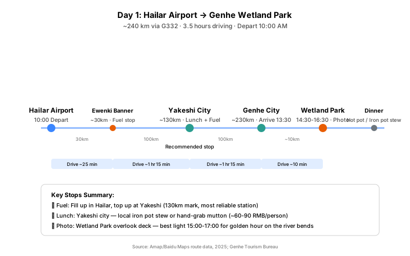
Route: Hailar Airport → G332 National Highway → Ewenki Banner → Yakeshi City → Genhe City → Genhe Wetland Park Distance: ~240 km | Driving time: ~3.5 hours | Departure: 10:00 AM
Hour-by-Hour Breakdown
| Time | Activity | Notes |
|---|---|---|
| 09:30 | Arrive at Hailar Airport, pick up rental car | Do a walk-around check: tires, lights, fuel level. Fill up at airport-area gas station. |
| 10:00 | Depart Hailar Airport | Take G332 east toward Yakeshi. Road is a 2-lane national highway, well-paved. |
| 10:30 | Pass through Ewenki Banner (~30 km) | Small fuel station available. No need to stop if you filled up at the airport. |
| 11:45 | Arrive Yakeshi City (~130 km) | Recommended lunch + fuel stop. Multiple PetroChina/Sinopec stations. Try local iron pot stew (铁锅炖) or hand-grab mutton (手把肉) — budget 60-120 RMB/person. |
| 13:00 | Depart Yakeshi | Continue east on G332 toward Genhe. Road conditions remain good. Occasional gentle curves through rolling hills. |
| 13:30 | Arrive Genhe City (~230 km total) | Check into hotel, drop bags. Genhe city center is small — 5 minutes to cross. |
| 14:00 | Depart for Genhe Wetland Park | The park entrance is ~5 km from city center. |
| 14:30 | Genhe Wetland Park | Admission: ~85 RMB/person. Walk the boardwalk to the overlook deck for the famous "Nine Bends" (九曲十八弯) river view. Best photos 15:00-17:00 when light is golden. Allow 2 hours. |
| 16:30 | Return to Genhe City | |
| 17:30 | Dinner in Genhe | Recommended: Genhe Extreme Cold Hot Pot (根河冷极火锅) or local iron pot stew. Budget 60-120 RMB/person. |
| 19:00 | Rest at hotel | Early night — tomorrow starts at 8 AM. |
Day 1 Driving Notes
- G332 is well-maintained but has occasional sections with gentle curves. Speed limit is typically 80 km/h. As a novice, maintain 60-70 km/h — you'll feel more comfortable.
- Watch for trucks: G332 carries freight traffic. Pass only when you have a clear, long straight view of oncoming lanes.
- Fuel strategy: Fill up at Hailar airport area, top off at Yakeshi (the most reliable large station on this stretch).
Day 2: Genhe → Aoluguya → Enhe → Shiwei
Route: Genhe City → Aoluguya Reindeer Tribe → Genhe (lunch) → S201/County roads → Enhe → Shiwei Distance: ~180 km | Driving time: ~3-4 hours | Departure: 08:00 AM
Hour-by-Hour Breakdown
| Time | Activity | Notes |
|---|---|---|
| 08:00 | Depart Genhe City | Drive ~4 km west to Aoluguya. |
| 08:30 | Aoluguya Ewenki Reindeer Tribe | Admission: ~80 RMB/person. Feed reindeer moss (~20-30 RMB/bundle), visit traditional birch-bark tents (撮罗子), learn about the last hunting tribe in China. Allow 2-3 hours. |
| 11:30 | Return to Genhe City | Lunch at local restaurant. Try鄂温克族风味 (Ewenk-style) dishes or simple noodles. |
| 13:00 | Depart Genhe for Shiwei | Head north on county roads toward Shiwei. Road transitions from paved highway to good-quality provincial road. |
| 14:00 | White Birch Forest section | The road passes through stretches of white birch forest at peak autumn color (mid-September). Safe pullouts available for photos. |
| 15:00 | Enhe Russian Ethnic Township | Recommended stop (30-60 min). Walk among the wooden "斯拉木" (Russian-style log houses). Buy fresh Russian bread (列巴) and blueberry jam from local families. Restrooms available. |
| 16:00 | Depart Enhe for Shiwei | ~30 km remaining, ~30 minutes. |
| 16:30 | Arrive Shiwei | Check into accommodation. Shiwei is a small border town on the Ergune River (额尔古纳河), across from Russia. |
| 17:30 | Sunset at Ergune River | Walk to the riverbank for sunset views. The river marks the China-Russia border. |
| 18:30 | Dinner in Shiwei | Local Russian-Chinese fusion cuisine. Try the river fish. |
| 20:00 | Rest | Set alarm for 07:00 — Day 3 is the longest drive. |
Day 2 Driving Notes
- Road from Genhe to Shiwei is mostly paved but narrower than G332. Some sections are single-lane with pullouts for passing. Maintain 40-60 km/h.
- Livestock alert: This stretch has frequent sheep and cattle crossings. Reduce speed to 40 km/h when you see animals near the road. Do not honk — it scatters them unpredictably.
- Enhe is the last reliable stop for food, fuel, and restrooms before Shiwei. Shiwei itself has limited services.
Day 3: Shiwei → Qi-Qia / Ba-Qia / Jiu-Qia → Heishantou → Hailar Airport (The Border Defense Road)
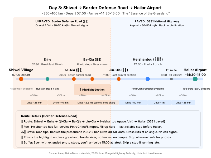
Route: Shiwei → Enhe → Qi-Qia (七卡) → Ba-Qia (八卡) → Jiu-Qia (九卡) → Heishantou (黑山头) → G331 → Hailar Airport Distance: ~350-400 km | Driving time: ~5.5-6.5 hours | Departure: 07:00-07:30 AM | Arrival: ~14:30-15:00 PM
Why Take the Border Defense Road (卡线)
Qi-Qia, Ba-Qia, Jiu-Qia — this stretch of border defense road is called "the essence of the grassland" (草原精髓), and it's the core experience of any Hulunbuir self-drive. You'll follow the Ergune River along the China-Russia border, with golden grassland on one side and the Russian mountains on the other. No fences, no traffic, no people — just endless prairie and the winding river.
Challenge for the Tharu: The border defense road is unpaved gravel/dirt (砂石/土路) with ruts and loose stones. The Tharu can handle it at reduced speed, but requires careful driving.
Border Defense Road Driving Tips (Must-Read for Novices)
| Technique | Recommendation |
|---|---|
| Speed | Maintain 30-50 km/h throughout. Never exceed 60 km/h. |
| Tire pressure | Reduce to 2.0-2.2 bar before the trip for better traction. |
| Ruts | Cross deep ruts at an angle, slowly. Don't plow straight through. |
| Oncoming vehicles | Slow down early, pull right to let them pass. Dust reduces visibility. |
| Pulling over | Only stop on flat, firm ground for photos. Do not drive onto the grass. |
| Water crossings | Shallow streams exist on the route. Do not attempt if deeper than 15 cm. |
⚠️ No cell signal on the Qi-Qia to Jiu-Qia stretch. Download offline maps beforehand and inform someone of your itinerary.
Hour-by-Hour Breakdown
| Time | Activity | Notes |
|---|---|---|
| 06:30 | Wake up, pack, check car | Quick walk-around: confirm tire pressure has been reduced, check fuel level. Fill up in Shiwei if available. |
| 07:00 | Depart Shiwei | Head south on S201 toward Enhe. |
| 07:30 | Enhe (brief stop, ~30 min) | Breakfast: Russian bread with blueberry jam, hot tea. Restroom break. Morning light photos of the wooden houses. |
| 08:00 | Depart Enhe for Qi-Qia | Leave the paved road. The surface transitions to gravel/dirt — the border defense road begins. |
| 09:00-12:00 | Qi-Qia → Ba-Qia → Jiu-Qia (The Highlight) | Drive along the Ergune River on the China-Russia border. Stop whenever you find a safe pullout for photos. Maintain 30-50 km/h. Watch for livestock. This is the visual climax of the entire trip. |
| 12:00 | Arrive Heishantou | Critical fuel + lunch stop. Heishantou town has PetroChina/Sinopec stations. Fill up. Lunch: iron pot stew or hand-grab mutton. |
| 13:00 | Depart Heishantou | Merge onto G331 national highway west toward Hailar. You're back on pavement — you can breathe easier. |
| 13:00-14:30 | G331 driving | 2-lane national highway, excellent surface. Speed limit 80 km/h. Maintain 60-70 km/h as a novice. |
| 14:30 | Arrive Hailar Airport area | Return rental car (if applicable). |
| Before 15:00 | At airport terminal | At least 1 hour before your 16:00 deadline. Comfortable margin. |
Day 3 Timing Flexibility
The border defense road has no strict schedule — you can linger at a viewpoint for an extra 30 minutes without consequence. Even if you:
- Spend an extra hour photographing the grassland
- Take a longer lunch break at Heishantou
- Stop multiple times for photos
...you'll still arrive at the airport by 15:00-15:30. If you're concerned about time, simply skip one photo stop on the border road.
Day 3 Driving Notes
- Dust on the gravel road reduces visibility when following other vehicles. Maintain extra distance.
- G331 from Heishantou to Hailar is the same quality as G332 — smooth, well-maintained.
- Livestock on the border road: Expect animals throughout. This is open grazing land. Slow down, don't honk, stop and wait if needed.
- The transition back to pavement (near Heishantou) feels like "returning to civilization" — that's when you can finally relax.
How Do You Handle Livestock on the Road?
This is the single most important safety topic for Hulunbuir self-driving. Free-grazing livestock (cattle, sheep, horses, and yaks) are present on roads throughout the region, and collisions are common enough that local insurance data shows animal-strike claims peak in summer and autumn (PICC Inner Mongolia, 2024).
The Rules
-
Slow down in grassland areas. When you see open pasture on both sides of the road, reduce speed to 40-60 km/h. Animals can appear suddenly from behind grass tufts.
-
Never swerve around animals. This is the most critical rule. On a grassland road, swerving can cause rollover (especially in an SUV with a higher center of gravity like the Tharu), send you into oncoming traffic, or put you off the road into soft ground. Brake firmly and stay in your lane.
-
Do not honk aggressively. A short, gentle tap is acceptable to alert animals ahead. Sustained honking panics them and causes unpredictable scattering — potentially into your path.
-
If a herd is crossing, stop and wait. Turn off your engine if the wait is long. The animals will clear the road on their own. Rushing through a herd is extremely dangerous.
-
Dawn and dusk are highest risk. Animals are most active during these periods. If you must drive during these times, reduce speed further and scan the road edges constantly.
If You Hit an Animal
- Stop immediately. Do not drive away — this is a legal offense.
- Call the police (110). You must file a report.
- Compensation is required: Cattle typically cost 10,000-20,000 RMB; sheep 2,000-3,000 RMB. Animals have ear tags with GPS tracking, so the owner will be identified.
- Document the scene: Photos of the animal, your vehicle damage, and the location.
- Contact your insurance: Comprehensive insurance (车损险 + 第三者责任险) typically covers animal-strike damage.
[UNIQUE INSIGHT] The "Never Swerve" Rule
The instinct when something appears in your road is to swerve away from it. On a city street, that's often correct. On a grassland road in an SUV, it's potentially fatal. The Tharu's center of gravity is higher than a sedan's, and a sharp swerve at 60+ km/h can initiate a rollover. Local drivers know this: they brake hard and stay straight. If you hit the animal, it's an expensive insurance claim. If you roll the SUV, it's potentially life-threatening. Brake, stay straight, accept the impact if unavoidable.
What Should You Pack for a September Trip?
Clothing (Layer System)
| Layer | Items | Why |
|---|---|---|
| Base | Thermal top + bottom (merino wool or synthetic), 2 sets | Morning cold, wicks sweat during activity |
| Mid | Fleece jacket, lightweight down vest | Driving layer, easy to add/remove |
| Outer | Windproof/waterproof shell jacket | Wind and rain protection |
| Warmth | Packable down jacket (羽绒服) | Mandatory for mornings and evenings |
| Bottoms | Quick-dry hiking pants, thermal leggings (under) | |
| Extremies | Warm hat, gloves, buff/scarf, sunglasses | Hands get cold on the wheel |
| Footwear | Waterproof hiking boots, wool socks (3 pairs) |
Vehicle Emergency Kit
| Category | Items |
|---|---|
| Tire | Tire pressure gauge, portable air compressor (充气泵), tire sealant |
| Traction | Tow rope (拖车绳), jumper cables (搭电线) |
| Visibility | Reflective warning triangle, high-visibility vest |
| Navigation | Phone mount, car charger, power bank (20,000 mAh+) |
| Comfort | Blanket (for breakdown in cold), snacks, water (1L per person) |
| Tools | Multi-tool, duct tape, flashlight/headlamp |
Personal Items
- Sunscreen SPF50+ — autumn UV at this latitude is still strong
- Lip balm — dry wind causes chapping
- Insect repellent — mosquitoes persist into early September
- Thermos — hot water is a luxury on cold mornings
- Cash (2,000-3,000 RMB) — some rural vendors don't accept mobile pay
- ID card — required at border checkpoints and police stops
Where Are the Fuel Stations and How Far Apart?
Fuel planning is critical on grassland routes. Running out of fuel in a remote area with no cell signal is a serious situation, especially in near-freezing temperatures.
Station Spacing on Your Route
| Segment | Distance | Stations | Recommendation |
|---|---|---|---|
| Hailar → Genhe | ~240 km | Ewenki (~30 km), Yakeshi (~130 km), Genhe (~230 km) | Fill at Hailar, top up at Yakeshi |
| Genhe → Shiwei | ~180 km | Genhe (start), Enhe (small), Shiwei (limited) | Fill up in Genhe before departing |
| Shiwei → Hailar (border road) | ~350-400 km | Shiwei (depart full), Heishantou (~150 km, critical), Hailar (dense) | Must fill at Heishantou — no fuel on border road |
The Half-Tank Rule
Whenever your fuel gauge drops to half, fill up at the next station. This gives you a safety margin for:
- Unexpected detours
- Traffic jams (rare but possible near construction)
- Cold-weather fuel consumption increase
- Finding a closed station (some rural stations have limited hours)
Fuel Quality Notes
- PetroChina (中石油) and Sinopec (中石化) are the most reliable brands. Stick to them when possible.
- In very remote areas, smaller independent stations may have lower-quality fuel. If you must use them, don't fill the tank completely — mix with known-good fuel at the next major station.
- 95号 gasoline is recommended for the Tharu's 1.5T/2.0T engines. 92号 is acceptable if 95 is unavailable.
Will You Have Cell Signal for Navigation?
Signal Coverage Map
| Area | Signal Quality | Notes |
|---|---|---|
| Hailar city | 4G/5G full | No issues |
| Genhe city | 4G good | Reliable |
| Shiwei/Enhe | 3G/4G variable | Present but can be slow |
| G332 highway | 4G most sections | Occasional dead spots in valleys |
| S201 riverside road | 3G/4G variable | Some gaps |
| Border defense roads (卡线) | None | Day 3 uses this route — download offline maps |
Recommendations
- Use China Mobile (中国移动) — it has the best rural coverage in Inner Mongolia.
- Download offline maps before departing:
- Amap (高德地图): Download Hulunbuir/Inner Mongolia offline pack
- Baidu Maps (百度地图): Download as backup
- Maps.me: Works fully offline, good for trail/area reference
- Don't rely on real-time navigation alone — study the route beforehand so you know which turns to take even without signal.
Frequently Asked Questions
Do I need a border permit (边防证) for this route?
For the paved route described in this guide (Hailar → Genhe → Shiwei → Enhe → Ergun → Hailar), no border permit is required. You stay within regular administrative areas. However, if you deviate onto actual border defense roads near the Russian border, you may encounter checkpoints requiring permits. Carry your ID card at all times — police checkpoints are common and you will be asked to show identification.
Can the Tharu handle the border defense road (卡线)?
Yes, with care. The Tharu handles light to moderate gravel roads fine (the Qi-Qia to Jiu-Qia section falls into this category). Key techniques:
- Reduce tire pressure to 2.0-2.2 bar before the trip
- Maintain 30-50 km/h
- Cross deep ruts at an angle, slowly
- Do not drive off the track onto soft sand or grass
The Tharu cannot handle: deep mud, large rocks, or water deeper than 15 cm. The border road gravel is milder than these extremes.
If heavy rain has turned the border road muddy and slippery, skip it and take the paved alternative (Shiwei → Ergun → Hailar). In September's dry season, the border road is typically in good condition.
What if it snows while I'm driving?
September snow is usually light and melts within hours. If you encounter snow:
- Reduce speed to 40 km/h or below
- Increase following distance to 3× normal
- Use low beams (high beams reflect off snowflakes and reduce visibility)
- If conditions feel unsafe, pull over safely and wait — snow in September rarely lasts more than a few hours
- The Tharu's stability control (ESP) will help, but it cannot override physics on ice
Should I book accommodation in advance?
Yes, absolutely. Mid-September is peak autumn viewing season (the golden birch window is only 2-3 weeks). Hotels and guesthouses in Genhe, Enhe, and Shiwei fill up quickly. Book at least 1-2 weeks ahead. In Shiwei and Enhe, the most desirable rooms are the traditional wooden log houses (木刻楞) — these book out first.
Is it safe to drive alone as a novice?
We recommend at least two people in the vehicle. Reasons:
- Driver fatigue is real on long, monotonous grassland roads
- A second person can navigate, watch for livestock, and share driving
- In case of emergency, having a companion is invaluable
- If you must drive alone, inform someone of your daily route and expected arrival time, and check in by phone at each stop
Conclusion
A mid-September self-drive through Hulunbuir is one of the most rewarding road trips in northern China — golden grasslands, birch forests in peak color, Russian-style villages, and the vast silence of the steppe. With a Volkswagen Tharu and the paved-route itinerary in this guide, a novice driver can complete it safely and comfortably.
The four rules to remember:
- Layer your clothing — 15-20°C temperature swings demand it
- Follow the half-tank rule — fuel up whenever you hit 50%
- Brake, don't swerve — for livestock on the road
- Stay on paved roads — the Tharu is capable, but this trip isn't about off-roading
Drive slowly, stop often for photos, and let the landscape unfold at its own pace. The grasslands have been here for millennia — they'll wait for you.
Sources
- China Meteorological Administration, Hulunbuir historical weather data, 2025, http://www.cma.gov.cn
- Amap (高德地图), Hailar-Genhe-Shiwei route data, 2025, https://www.amap.com
- Baidu Maps, Inner Mongolia road network data, 2025, https://map.baidu.com
- Genhe Tourism Bureau, Genhe Wetland Park visitor information, 2025
- Volkswagen China, Tharu 2025 model specifications, https://www.vw.com.cn
- PICC Inner Mongolia, vehicle insurance claim statistics, 2024, https://www.picc.com.cn
- Inner Mongolia Highway Authority, G332/S201 road condition reports, 2025
- Mafengwo, Hulunbuir self-drive travel guides, https://www.mafengwo.cn
- Zhihu, Hulunbuir driving experience reports, https://www.zhihu.com